We have all seen lightning at some point or another. It splits the sky without warning, shakes the air with thunder, and shows the immense energy nature can release in an instant. As impressive as lightning appears from the ground, its true complexity often goes unnoticed. What many people do not realize is that not all lightning strikes downward. Some forms of lightning travel upward toward space, forming brief and subtle displays high above storm clouds.
These events can appear as faint red flashes spreading across the upper atmosphere or as narrow blue columns rising from the tops of thunderstorms. Most people are unaware of them, largely because they occur very quickly and far above the clouds where they cannot be seen easily. Two of the most studied examples of this type of lightning are red sprites and blue jets.
Unlike ordinary lightning, which occurs within clouds or between clouds and the ground, red sprites and blue jets take place above thunderstorms in regions of the atmosphere with much lower air density. Red sprites typically appear at altitudes between 50 and 90 kilometers above Earth, extending into the lower mesosphere. Although they can span tens of kilometers in height, they last only a few milliseconds. Blue jets occur at lower altitudes, usually between 15 and 50 kilometers, and emerge directly from the tops of thunderclouds as narrow upward-moving discharges.
In addition to red sprites and blue jets, researchers have identified several other types of transient luminous events that briefly illuminate the upper atmosphere.
- ELVES: Brief, ring-shaped flashes that expand rapidly high above thunderstorms, caused by lightning interacting with the lower edge of the ionosphere. They last less than a millisecond.
- Blue starters: Short-lived blue discharges that rise from the tops of storm clouds but fade before developing into full blue jets.
- Gigantic jets: Rare, large-scale events that extend from thunderclouds all the way toward the ionosphere, reaching altitudes similar to red sprites.
Because of where they form, these phenomena remained hidden for most of human history. Thick cloud layers block the view from the ground, and their short duration makes them easy to miss even when conditions are favorable. It was only when humans began flying at high altitudes that the first clues appeared. Pilots flying above thunderstorms occasionally reported strange flashes and glowing shapes above the clouds, but these early observations were often dismissed as visual illusions or reflections.

The situation began to change with the use of high-altitude research aircraft. Aircraft flying above or near storm systems were able to observe the regions just above cloud tops, providing a new perspective that was impossible from the ground. With the development of sensitive low-light cameras, researchers were finally able to capture images of brief red and blue flashes occurring above storms. These airborne observations confirmed that the pilots’ reports had a physical basis and that lightning-related processes were extending far beyond the cloud layer.

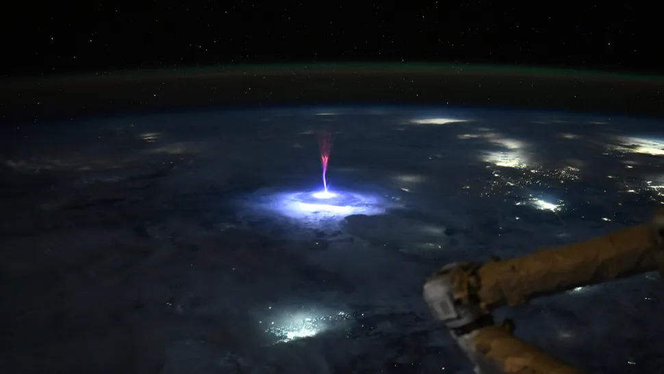
Even so, aircraft could only provide a limited view. The most revealing observations came from space. Astronauts aboard orbiting spacecraft and later the International Space Station had a unique vantage point, looking down on thunderstorms from above. From this perspective, the upper atmosphere becomes visible against the darkness of space, making faint electrical events easier to detect. Cameras mounted on the station recorded red sprites spreading across the upper atmosphere like soft flashes and blue jets rising from cloud tops in narrow columns. These images provided some of the clearest and most convincing evidence that thunderstorms interact electrically with regions close to space.

One of the most noticeable differences between red sprites and blue jets is their appearance. Red sprites have a diffuse red glow and often form branching or filament-like structures. This coloration is caused by the excitation of nitrogen molecules in the thin upper atmosphere. At such altitudes, the low air pressure allows electrical discharges to spread out more easily, producing broad and delicate shapes rather than sharp lightning channels.
Blue jets appear more concentrated and structured. They are typically blue in color and rise upward in a cone-like form. The denser air at lower altitudes restricts the spread of the discharge, resulting in a more focused and directional event. Although both phenomena involve similar atmospheric gases, differences in pressure and density strongly influence how the electrical energy propagates and how it appears visually.

The mechanisms that produce red sprites and blue jets are still being investigated. Red sprites are often associated with strong cloud-to-ground lightning strikes, particularly those involving large transfers of positive electrical charge. These strikes can momentarily enhance the electric field above a storm, creating conditions that allow an electrical discharge to occur in the upper atmosphere shortly after the main lightning event.
Blue jets appear to originate from within the thundercloud itself and are not always linked to visible lightning strikes. They are thought to form when electric charge accumulates near the top of a storm cloud and the surrounding electric field becomes strong enough to drive an upward discharge. The precise conditions that lead to their formation are not yet fully understood.
Red sprites and blue jets continue to occur above thunderstorms around the world, usually unnoticed. While attention is often focused on lightning at the surface, observations from high-altitude aircraft and orbiting platforms have revealed that the atmosphere above storms is far more active than once believed.

Leave a Reply